with duck ant Close up of display
with duck ant Close up of display
This unit was made for use in Desert Storm/Shield and has a special option that includes the Military Grid Reference System (MGRS) and UTM coordinates in addition to the Normal Lat - Lon coordinates. There are a number of map datums built into this unit.
There is provision for a 9 Volt battery, but the battery compartment is large enough to hold the supplied 6 AA battery holder. This holder supplies 9 V, but with much more capacity than a normal 9 Volt battery an has a standard 9 Volt snap connection. This allows the use of either a normal 9 Volt battery or the 6 AA holder by just snaping in the one you want to use.The first time you use the receiver you need to tell it within 3 degrees your Lon and Lat. This is to define the Loarn-C chain that will be used. If this is not done it could take a hour for the receiver to try and lock on every chain in the world.
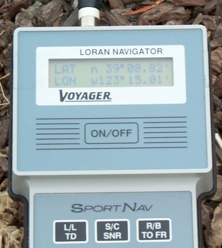
The Lat Lon display reads out to 0.01 Minutes.
My location is 39:11.411533 North by 123:09.842467 West based on a fixed GPS antenna.
The SportNav gives me position as:
GPS SportNav Lat 39:11.411533 Nh 39:10.14 N Lon 123:09.842467 W 123:07.58 W The Signal strength is very weak inside and even outside you need to be away from the house and trees to get reasonable signal strength. The manual suggests clipping a ten foot long wire to the belt clip to improve the ground. If the wire is not used you need to tough the belt clip with your hand to provide a counterpoise. I would be interesting to connect my active antenna and then let it settle to see the reading.
The Lat Lon display always is blinking, which should stop when the receiver thinks it has a fix. Maybe in my location an active antenna is the only option for a good fix?
Universal Transverse Mercator (UTM) and Military Grid Reference System (MGRS) -Back to Brooke's Products for Sale, Astronomy, CCD Astronomy, Sundials, Surveying, Time & Frequency, Military Information, Home page
Defense Mapping Agency Technical Manual 8358.1 Datums, Ellipsoids, Grids and Grid Reference Systems. - may be down due to war
Geographer's Craft - Coordinate Systems Overview - MGRS - UTM - by Peter Dana
This is the [an error occurred while processing this directive] time
this
page has been accessed since since 20 Oct 2001.