| |
|
| |
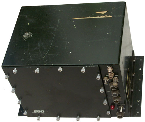
This is a first generation GPS receiver intended for mounting in a military vehicle.
R-5133/URN-502 Receiver Box
There are no user controls or indicators except for the on/off switch.
This 11 3/8" high x 15" wide x 12" deep box has a removable front panel to allow access to the printed circuit boards inside.
It was made by EDO in Canada.
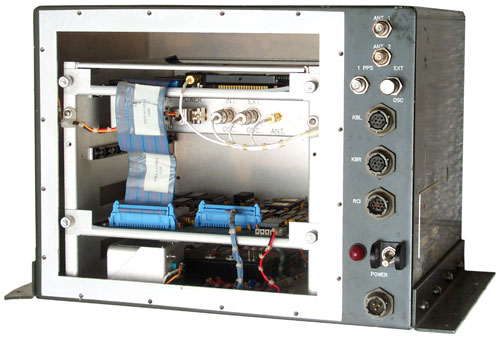
Front Panel:Inside:
- Ant 1
- Ant 2 - no internal connection
- 1 PPS out
- Ext Osc
- KBL - KeyBoard Local: A-Gnd, B-J104#5, C-J104#2, D-J104#4, E-J104#8, F na, G+H+E-Red keying pins, K-Gnd
- KBR - KeyBoard Remote: A-Gnd, B-J104#22, C-J104#19, D-J104#24, E-J104#25, F na, G+H+J-red keying pins, K-Gnd
- RCI - Remote Computer Interface: A-J104#10, B-J104#11, C-J104#12, D-J104#13, E-J104#14, F-J104#15, G-J104#16, H-J104#17, J-Gnd, K-?
- Power On lamp
- Power Switch
- Power connector - ITT 8816 KPSE 07E12-3P, A=20 to 60 VDC, B & C = Ground
Stk 5825-21-905-2372
- Intronics Inc. DC to Dc Switching Power Converter KZ438-01, on bottom of box
- Toyocom - TCO-634 10.0 MHz Osc, +12 VDC in, TTL out, on bottom of box
- Logic PCB - 68020 based, P2 at front edge goes to the top board assembly, P4 has J104 that goes to the DC power terminal strip on the bottom of the box. I expect that this board handles the I/O functions for the dumb control unit. It reads the commands that select the display type and generates the 4 lines of data for the LCD.
- Top Board Assembly contains CMOS RAM and a 3.6 V Lithium battery on a printed circuit board (JRC - CMJ-174B Data Procession Unit made in Japan).
The front wide ribbon cable goes to the Logic board, the SMA(f) is the 1PPS out SMA(f) J3, and the smaller ribbon cable at the back goes down to the metal box. There is a 40 pin IC under a heat sink marked: LC8887-2, I7332010, copyright '88 '84 and it's right next to an NEC 40 pin chip marked:
8704FX V30
D70116D -8 Copyright '84 NEC
Attached under it a metal box with the following connectors:Inside the metal box is a JRC CMA-202 Receiving Unit, PCNA0621A.
- Test Points for: +9 (Yel from 7809 on CMA202), +5, +12 and GND
- DB9(m) Power connector 2 Black (Gnd) , Red (+5) and Orange(+12) wires.
- BNC(f) Int Osc to Toyocom
- BNC(f) Ext Osc to front panel conn (P304)
- SMA(f) to Front Panel Ant 2
This is a GPS receiver analog front end made with discrete components.
A 20-wire ribbon cable (J2) connects it to the CMJ-174 printed circuit board.
There is a 74HC04P right next to J2 so the ribbon cable carries TTL logic.
The Antenna connector goes near the two metal boxes.
The Ext Osc goes to the other SMA connector.
The Int Osc cable goes under the board.
I expect that this assembly takes care of the GPS specific things like decoding the nav messages and finding the pseudo ranges.- There is an empty slot between the Logic board and the top assembly. The Logic board has designators for sockets and chips that are not populated indicating that there was a plan for another function and board.
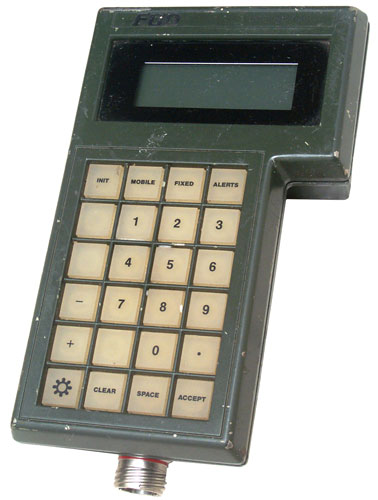
EDO 4053-98-0200 Control Head
This is the control and indicator for the system.
It can be hand held or mounted on a 45 deg. bracket in a vehicle.
It appears to be a mil spec version of the OT40 made by WPI Termiflex, Inc.
It may be the WPI model MP2105.
There is an EL back light for the 4 line by 20 character LCD.
There is a 10-pin nil connector on the bottom that mates with a cable connector M85049/38-13W.AS-5191/URN-502 Antenna(s)
Approximately 5" dia x 2" high single choke ring passive antenna with TNC(f) connector.
The upper white plastic dome is held on by an o-ring and can be removed by twisting.
Stk 5985-21-905-2583
DND Canada Mdn
PT/PC 4053-98-0220
Contr. W8474-7-MZ1F
Ser. 92-004Cables
Control Head to Extension Box 4053-98-0213 has ITT 8816 KPSE06E12-10P connector on one end that mates with the receiver panel connectors and Pyle D38999/26FC98SN on other end.
The remote box has a plug that mates to the receiver box and duplicates the receiver box connector (i.e. it's an extension cord).The Antenna to receiver box cable is a TNC(m) to TNC(m) cable 18 feet long.
Bracket
This will hold the Control Head (with a strap) at 45 degrees in a vehicle.
4053-50-0212 Rev. 1.00
Power On
At power on the LCD shows in the upper left corner:Pressing INIT:
- CPU TEST
- IRM TEST
- ERM TEST
- DLP TEST
- ROM TEST
- KEY TEST
- all "#" characters in display
- all "M" characters in display
- all "I" characters in display
- SELF TEST PASSED
- AUTOMATIC
POSITION
CORRELATOR
EDO CANADA
- SYSTEM = UTM (press "space" for "LAT-LON") then press "ACCEPT"
- DATE = DD/MM/YYYY enter 20121997 (for 20 Dec. 1997) press "ACCEPT"
- TIME = HH MM SS (UTC)
- GMT OFFSET = hh:mm (hh = -23 to 23 & mm = 0, 15, 30, 45)
- DATUM = NAD27 (Local, Eup50, NAD27)
- INIT LAT = 39<space>23<space>12<space> press "ACCEPT"
- INIT LON = -123<space>09<space>50 press "ACCEPT"
- INIT HEIGHT = 250 (meters) press "ACCEPT"
- START SYSTEM = YES press "ACCEPT"
Display:
Pressing + or - toggles between speed and height for the bottom line.
Mobile Display:
20/12/97 15:33:56 M*
lat= 37 23 12.0
lon=-123 09 50.0
spd=000.0 crs=090.0 0<blinking square>Fixed Display:
20/12/97 15:36:03 A*
LAT= 39 23 09.3
LON=-123 09 47.2
HGT= 0250 <blinking square>Alerts Display:
20/12/97 15:38:06 M*
TRACKING=00 <blinking square>
15H 16H 17H 18H
*** *** *** ***
The last two lines are a visibility forcast for 4 hours into the future.
The display was at 15:00 hours and the forcast is for 15:00, 16:00 17:00 and 18:00hours.
Brooke's Products for Sale, Military
Information, Home Page
This is the [an error occurred while processing this directive] time this page has been accessed since 6 Aug 2000.