 |
 |
 |
 |
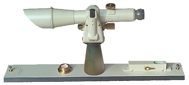
| Left |
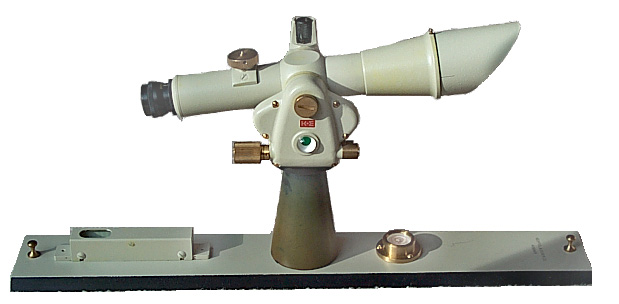
Right |
Right K&E
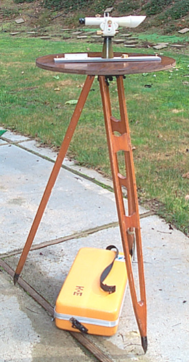
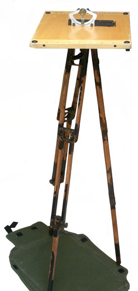
Tripod & home made table |
M1913 Sketch Set Surveying Military, Field Sketching |
| |
|
|
|
| Left |
Right |
Right K&E
Tripod & home made table |
M1913 Sketch Set Surveying Military, Field Sketching |
General Alidade
Form the care and adjustment of K&E SURVEYING INSTRUMENTS brochure is a description of why you would use an Alidade:The only on line government manual for an alidade is TM 5-6675-211-15P Alidade, Surveying: Telescopic w/accessories and carrying case (Dietzgen Models 6230) 10 to 18 power (FSN 6675-190-5260) and (Model 6220) 12 to 24 power (6675-190-5261){TO 49A1-2-14}"Plane Table (M1913 Sketch Set) Alidades provide the best means of mapping small areas and of completing details between survey control points. They are also important in areas that aerial photographs will not detect objects because of size or forest cover. Plane table mapping has three important advantages over other types of ground mapping:
1 . All direction measurements are instantly recorded on the map. The intervening processes of recording field notes and plotting them are eliminated.
2. The map is constructed at once, in the field, so that no permanent records are necessary other than the map itself.
3. The topographer sees the ground that he is mapping. He can draw a more perfect representation of the ground and yet use fewer field observations.
In cooperation with the U.S. Geological Survey, K&E has developed the K&E Paragon® Self-Indexing Alidades."Alidades were the primary mapping instrument in the U.S. from about 1865 to the 1980s. They were replaced by the total station.
Transits and/or theodolites were used to establish boundaries and to locate key points but the plane table and Alidade was used to fill in the detail on a map. The surveying alidade is used on a table whose surface is level (plane). This is a requirement so that lines of bearing are correct.Very early alidades might have been as simple as a straight stick with raised sights similar to those on a rifle. No optical parts would be involved. With this you could draw a line of bearing on a map. Determining true or magnetic North and the distance to any target would need to be done using other means.
K&E Paragon® Self-Indexing Alidades
In my opinion this instrument is one of those made at the peak of alidade development. Instead of using a vernier scale to read vertical angles this instrument uses optical scales similar to those on a Theodolite but with enhancements to aid in its use.Distance is determined using the method of stadia. In this method the distance to the target is the stadia intercept on the rod times 100 feet if the sight is level. As the angle to the rod deviates from level the distance measured in a horizontal plane (the way maps are made) decreases by the cosine squared of the deviation angle, alpha.
Self-Indexing
There is a damped pendulum that is operational when the bubble in the circular level is within the outer circle. It compensates for the base of the alidade being out of level so that vertical angle measurements are accurate even when the base of the alidade is slightly out of level. This is a good thing because the table does need to be perfectly leveled.There are three scales that are read optically, two of which do the trig calculations so only a single multiplication is needed to find the horizontal and vertical distances from the center of the instrument to the centerline reading on the rod.Because of this it's important the the base of the alidade is not tilted between the time the sight is taken and when the optical scales are read. If for example the table is tilted slightly after the sight, even though the alidade is not disturbed, the reading will have an error due to the self leveling.
Vertical stadia mult
scaleZenith Dist
scaleHor stadia mult
scaleVertical angle (a) v = 100 * SIN(a) * COS(a) = 100 * COS2(|a|) = 90 - Z up 10 deg 67 80 97 10 Level 50 90 100 0 down 13.7 deg 27.0 103:42 94.4 -13.7 Example from manual uses the down 13.7 degree data and the stadia intercept on the rod is 5.3'
Horizontal distance is now 5.3 * 94.4 = 500.32'
Vertical separation is now 5.3' * (27.0 - 50) = -121.9'If the Height of the Instrument (HI) was known to be 525.7' and the centerline read 4.7' on the rod then the elevation at the base of the rod is:
525.7' HI
- 121.9' separation
---------
403.8'
-4.7' rod reading at centerline
--------
399.1' elevation at base of rod
The brochure calls the above method Stadia arc method.It is not clear if there is a 1 foot adder for close distances, like on a typical transit.
There appear to be two versions of most manufacturers Alidades. The tall version, like this one, that comes in a rather large case, like would be convenient to carry in a car. The short version that would be packaged in a very small case designed to be carried by someone in the field. K&E refers to the smaller version as the "Expedition". The 1949 model N5095A Expedition Alidade weighs 5 lbs whereas the N5093A Geological Survey Alidade weighs 7 lbs.
This booklet has the following sections about this Alidade:
This booklet mentiones that for "internal focusing" instruments the C=1 foot factor has become negligable so the distance is just 100 * the stadia intercept. Older external focusing instruments use Dist. = 100 * S + 1 (all in feet).
- Introduction
- Features
- Operation
- Making an Observation
- Field Adjustments
- Shop Adjustments
- Parts Drawing
- Parts List
In the 41st Edition of the K&E catalog (1949) there is a description of "internal focusing" and it's benefit that it keeps the inside clean. An external focusing instrument creates a vacuum when the objective is extended, sucking in dust.
Other 76 0000 Alidade were made for the U.S. government with NSN 6675-00-756-1836 on contract DAAJ09-80-C-5015.
I got this tripod separately on eBay. The head has a dual function in that when the upper wing nut is loosened the head and be adjusted for level. Once that is done and the upper wing nut is locked the lower wing nut can be loosened, allowing the table to rotate but not tilt.
The head has a male 5/8 - 18 thread to mate with the table NOT the standard 5/8-11 surveying tripod thread (WHY?).
2023 Oct 14 answer from Mike:
In the early 1900's the need for this equipment was growing rapidly, and a major customer was the federal government. There were several different manufacturers of instruments, tripods/boards and other supplies, and I do not think they were always compatible between companies. I assume that there was determined to be a need by the Fed's for some level of standardization, so reports back to HQ from the surveyors would have been requested identifying troubles in procurement, compatibility and usefulness as well as suggestions for a better set-up. Ultimately it appears the Gov't determined what it needed and informed the various makers of surveying equipment what that was. I believe the adoption of a different thread size was an effort to avoid favoritism towards any of the companies by making ALL of them use the new "Standard" thread size for new equipment to be purchased by the Federal Government.
Home Built
By having my local Babe's muffler shop weld a 5/8-18 nut to a 4.75" square electrical cover plate and inlaying this into a piece of plywood, I made my own table that attaches to the tripod. A 2 foot diameter table holds a "B" size drawing with room for other stuff.
K&E Sketching Boards
There appear to be Models 1913 and 1917. These probably refer to years since part of the instructions on the back of the 1917 Model has to do with how to carry the board on horse back. Also the 1917 Set included three seperate collapsible legs and an attaching disk so the board could be used without a tripod.
At the first office supply store I tried clerk had a blank look on his face when I asked about "B" size paper. I tried another office supply and said I wanted 11 x 17" paper and they said "Oh, Ledger paper" and gave me a couple of sheets from their copy machine. Getting Mylar "B" size drafting paper will require a trip to a specialized store.
care and adjustment of K&E SURVEYING INSTRUMENTSBack to Brooke's Products for Sale, Navigation Orientation & Position, Alidade, Sundials, Surveying, Time & Frequency, Military Information, Home page
This booklet has information on the following K&E instruments:
74 0005 Transit
74 0150 Transit
75 0000 Tilting Level
75 0300 Dumpy Level
76 0000 Plane Table Alidade
76 0010 Plane Table Alidade
75 0020 Zeiss Ni 2 Self-Leveling Level
81 0537 Lovar Precise Rod
76 0330 Ranger IV EDM
76 0350 Ranger V EDM
76 0354 Rangemaster III
76 0365 Uniranger EDM
Vectron = Autoranger on top of a K&E theodolite but no theodolites are covered in this bookletK&E also made:
- the LeRoy lettering sets that used a 3 legged hand operated pen holder to draw letters. A different template was needed for each size or font
- drafting machines
- Slide Rules ( I used one in college since digital electronics and hand held calculators had not yet been invented. The Frieden mechanical calculator was in lab rooms and could do +, -, * and /. Curta had a hand held mechanical calculator advertised in sports car magazines for use on rallies, but they were expensive.)
- The Brunton pocket transit was also patented by K&E. US Patent 1,571,697 Transit Feb 2 1926
Page created 2 Jan 2003.